Burn Braes map
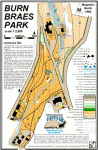
Burn Braes Park is the Site of several of the Museums for which Biggar has gained national recognition.
At the North end of the map stands Greenhill Farmhouse which was rescued from dereliction on its previous location at Wiston to form a Covenanting museum, reminding us of the signing of the National Covenant, The Civil War, and the “Killing Time”.
Area used for:
Near: Biggar, GoogleMap, OS Grid ref. NT 039380
More Information about the area
Carmichael Old House 1
Copy of the Old House Wood Map circa 1750.
Area used for:
Near: , GoogleMap, OS Grid ref.
Lanark Racecourse map
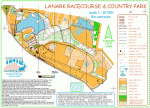
Orienteering began at Lanark Racecouse in January 1987 when over 400 competitors took part in an open event organised by SAOC (now STAG). The map and this competition provided the foundation for Tinto Orienteering Club which was formed in October 1987.
Area used for:
Used for:Lanark Racecourse – 4 May 2010
Used for:Lanark Racecourse Country Park – Wednesday 16 May 2018
Used for:Tinto Twin-Scottish Score Champs, 1/2 Nov 2008
Used for:Tinto Twin Night Event 2013 – Lanark Racecourse
Used for:Training Activity, Lanark Loch and Racecourse, 6 May
Used for:Training Activity, Lanark Loch and Racecourse, 19 May
Near: Lanark, GoogleMap, OS Grid ref. NS 900427
More Information about the area
Rachan and Dreva Hill map
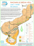
Mapped areasThe prominent geographical position of this area is evident from the early signs of both habitation and fortification.
Area used for:
Used for:Rachan, 8th Sept 2009
Used for:SOL 7 and Twenty Fifth Tinto Twin Day Event
Near: Broughton, GoogleMap, OS Grid ref. NT 137354
More Information about the area